1. What is the landscape of Iran?
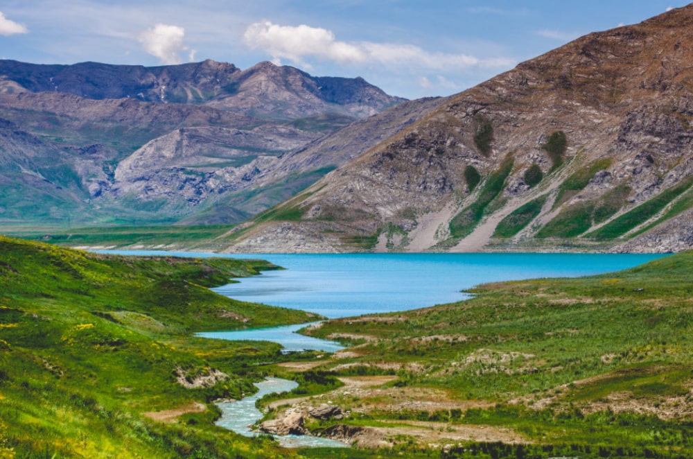
Iran is a rough country of uplands & mountains.It is dominated by the Alborz Mountains in the North and the Zagros Mountains along the Western borders. The Central and Eastern sections are covered by the Plateau of Iran.
2. What are the major bodies of water in Iran?
The leading lakes in Iran are:
- The Caspian Sea (the largest lake in the world)
- The Lake Urmia (the second largest lake in the world)
- Gahar Lake
- Bakhtegan Lake
- Parishan Lake
- Nayriz
- Namak
- Gavkhoni
- Nero
- Zaribar
- Maharloo
- Hamoun
- Houz Soltan
Most of the rivers in Iran are dehydrated, and the only navigable river is the Karoun River in Khuzestan. The floods in Iran flow into four major basins of the Caspian Sea, the Persian Gulf, the Sea of Oman, the Lake Urmia and the internal watersheds.
3. Is Iran prone to earthquakes?
Iran is one of the most seismic active lands in the world. It’s crossed by several major faults that cover at least 90% of the country. Earthquakes in Iran occur often and are destructive. The earthquakes have destroyed many of the towns throughout history. In the modern era was destroyed by the shock of two cities of Tabas and Bam.
4. Are there forests in Iran?
Yes! Iran Forests: green stillness. More than one-tenth of Iran is forested. A mild climate, plentiful rainfall, and a long growing season have combined to make a dense forest of high-quality timber in the Caspian region. Moreover, more than 2,000 plant species are grown in Iran.
55.5% to oak forests in the west of Iran. 19% is the woods in northern. Caspian Hyrcanian mixed forests are the last Unicef sites in Iran.
13.3% are scattered forests in the south and east. 13.3% is Aras mountainous forests, and 6.6% is, to tropical forests and desert forests.
5. What are the most prominent peaks of Iran?
The most prominent peaks of Iran are:
- Damavand: 5610 meters
- Alamkooh: 4850 meters
- Sabalan: 4811 meters
- Hazaran: about 4500 meters
- Dena: 4450 meters
- Zardkuh: 4250 meters
- Oshtoran Kuh: 4250 meters
- Shirkuh: 4075 meters
- Qalikuh: 4050 meters
- Taftan: 4025 meters
- Garrin: 4000 meters
- Bel: 3943 meters
- Neyzevaa: 3810 meters
- Barm Firuz: 3720 meters
- Ronj 3708: meters
- Sahand: 3700 meters
- Alvand: 3700 meters
- Mishu or Alamdar: 3000 meters
- Paraw: 3405 meters
6. What is the highest point in Iran?
The highest point is Damavand peak, at 5610 meters.
7. Are there any volcanoes in Iran?
There are 8 volcanoes in Iran. It has some active intraplate volcanoes, most notably Mt Damavand stratovolcano, which is also the highest mountain of the Middle Eastern region.
8. Does Iran have deserts?
Yes. The central desert (Markazi) is the largest in Iran. It extends from the southern slopes of Alborz to the center of Iran.
Its length is 800 kilometers, and its width is about 600 kilometers. The area of the Desert plain is about 60077 square kilometers. You can go to one of the following deserts with the professional tour guide:
Mesr desert
The best time to traveling in Mesr desert is from mid-fall to late April and is 700 kilometers far from Tehran.
Khur and Biyabanak desert
The eastern desert of Khur with honeycomb forms and dunes that come in various shapes with the wind blowing as well as Salt Lake of Khur are among the tourist attractions in the area.
Khur desert locates near Mesr desert.
Zardgah desert
Zardgah is located at 180 km from Tabas and is known as the greenest desert in Iran and owes this green area to the palm trees of this village. Zardgah village is a stepped village, and its attractions include a hot spring and a small pool for swimming.
Maranjab desert
Maranjab desert is located 300 km from Tehran and is the most popular tourist destinations in Iran.
The yardangs of Lut desert
Yardangs are burning lands free of any plant and animal life, and even the bacteria cannot live in such places due to temperatures of around 70 ° C!
The world’s largest yardang is the yardang of the Lut desert, which is a masterpiece of wind, soil, and water. These natural structures are made by wind dancing in the desert.humans do not have any effect on their construction, and they are still evolving due to permanent erosion.
Rig Zarin desert
Rig Zarin desert of Moghestan is located at 40km from the north of Bafgh in Yazd province. The Hajiabad Zarin heights are found in the northern part of this desert, which has a northwest-southwest direction, and the southwest part of the desert is covered with salt domes.